About DataDrone: Drone Services Ireland
DataDrone has been a leading provider in terms of professional Drone Services Ireland since 2017, specializing in high-accuracy aerial mapping and surveying. We began with prosumer level hardware which, while well suited to data collection jobs on a smaller scale suffers efficiency issues for larger jobs in terms of data collection, processing and overall project timeline. Since 2021 we began to take on larger and more complex aerial surveying tasks and have invested in advanced hardware in order to be able to meet the demands of such jobs with appropriate levels of efficiency.
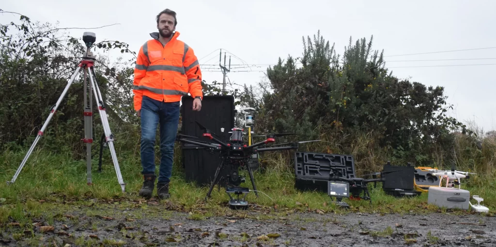
We invested in the M600 Pro drone and associated hardware in order to be able to carry out photogrammetry for larger survey jobs by developing/integrating it into a platform from which to collect very high resolution imagery which when paired with a wide angle lens means being able to fly higher and with wider flight lines to be able to map/survey the same area quicker while maintaining the same levels of accuracy through the use of GNSS and PPK technology and while also maintaining the same target resolution measured by ground sampling distance (GSD) which is the area on the ground a pixel represents (x cm/px).
Advanced Drone Services Ireland for Large-Scale Projects
We have further invested into sensor technology by acquiring a Velodyne GNSS/IMU LiDAR which can be used, particularly over vegetated areas to much more quickly generate point clouds which can be used to create elevation models (DEMs) and contour lines while also providing foundational data for additional measurements/provision of additional digital products.
We have invested in an additional heavy lift drone in the form of the M210 to improve efficiency another step whereby we are developing a triple sensor payload platform (RGB camera, LiDAR and multispectral camera). More recently we have invested in the flagship M300 RTK platform for multi-sensor operations.
Our technologies are treated as tools and we aim to use the most applicable tools for client purposes. We strive to push the boundaries of the technology by remaining at the forefront of the sector, the hardware and the software in order to take on projects of increasing levels of complexity to provide clients with data that would prove otherwise prohibitively expensive to acquire and which we can be relied on to collect and process where others struggle, due to our more advanced levels of hardware, software, sensor technology and systems integration.
Professional Deliverables & Data Standards for Drone Surveying Ireland
Our focus is on high-density geospatial data. The value isn’t in the flight itsled, but in the compatibility and accuracy of the data we provide. We provide standardised outputs to integrate directly into professional CAD and GIS environments.
Our current capabilities allow us to produce:
High-Resolution Orthomosaics: a few centimeter GSD that allows for detailed site inspection, overlays, digitisation.
- Topographic Models: Generating clean Digital Terrain Models (DTM) by filtering out vegetation and surface noise, providing the “bare earth” data needed for accurate contouring/baselines for volumetric reports.
Volumetric Reports: Utilizing photogrammetry and LiDAR to calculate stockpile volumes and earthworks with high precision, which is essential for quarrying and construction management.
Data Compatibility: We provide data in formats that matter to your workflow, including .DXF, .DWG, .tif and GeoJSON, ensuring seamless imports into GIS or AutoCAD software. We also do web mapping to host data online which can be shared via a link.
By focusing on these technical outputs, we ensure that our Drone Services Ireland provide a tangible ROI, reducing the time and cost of traditional ground-based surveying while maintaining rigorous engineering standards.
Safety, Insurance, and Compliance as applied to Drone Services Ireland
We are licensed by the IAA to fly our smaller and heavier aircraft under the EU (Drone) Regulations 2019/947 and 2019/945 and operate under the Specific Category. We are insured up to €6.5M.