
Drone Stockpile Measurement Ireland
Accurate Drone Stockpile Volumes & Tonnage Calculations
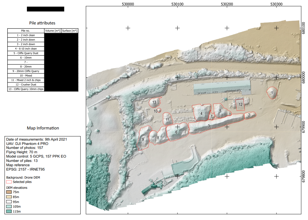
We provide drone stockpile measurement Ireland-wide. We can use an existing topographical ground profile from which to perform cut and fill calculations on, or create our own for the same workflow. Multiple site visits can improve topographical information e.g. where a subsequent survey covers an area on the ground where material was previously placed so that future material placed on the same area can be more accurately cut/fill calculated.
Accurate Drone Stockpile Volumes & Drone Tonnage Calculations
Our aerial surveys provide Accurate Drone Stockpile Volumes by capturing millions of data points across the site with computed and georeferenced point clouds. Sufficiency of data points are created for the “toe” and “crest” of every pile.
We translate this 3D data into actionable Drone Tonnage Calculations tailored to your site’s specific material densities, whether its crushed aggregates, topsoil, or coal in a coal yard, our reports provide the correct weight of material on the ground. This ensures your monthly audits are audit-ready, reflecting the true financial value of your assets for internal accounting and external stakeholders.
Drone Volumetric Analysis & Cut and Fill Analysis
For complex infrastructure and road projects, understanding terrain changes is vital for tracking haulage costs and staying on budget. Our professional drone volumetric analysis utilizes point clouds georeferenced through the use of RTK and PPK technology. This allows us to perform detailed drone cut and fill analysis, comparing current topography against baselines or specific design elevations.
For the quarring industry, our non-intrusive surveying methods are fully compliant with HSA Safe Quarry Guidelines, as it removes the need for personnel to climb unstable stockpiles or work near active heavy machinery.
Clients receive deliverables in .dxf, .dwg, .tif and las formats, ready for immediate integration into AutoCAD and GIS software as well as pdf and web GIS formats for each of data viewing and sharing. By digitizing your earthworks, we ensure that material moved is accounted for and documented.
Frequently Asked Questions
How accurate is drone stockpile measurement? Using sufficiently overlapped, high resolution drone imagery, we achieve centimeter-level horizontal and vertical accuracy. What this means for Irish quarry inventory, provided that accurate baseline topography is present, are margins of error in the low single digit percentages, which can be more reliable than traditional manual GPS “walking” surveys.
Can you calculate tonnage from drone data? Yes. By applying your site’s specific material density factors (e.g., 1.6 tonnes per cubic meter for crushed stone) to the captured volumes, we generate precise reports. This is essential for monthly financial audits and ensuring your “book vs. physical” inventory matches up.
What deliverables do I receive? We provide comprehensive reporting, including high-resolution orthomosaic maps (.tif), pdf volumetric reports, and engineering files for integration with CAD and GIS (.dxf, .dwg, .tif and .las).
Our On-Site Surveying Process
To ensure the highest levels of data integrity and site safety, we follow a process
Mission Planning & Risk Assessment: Before arriving on-site, we conduct a remote site survey, risk assessment and airspace check (and make any IAA UF101 applications necessary). We carry out a site survey of the site then once on site.
GCP & Base Station Setup: We utilize GNSS base stations and Ground Control Points (GCPs) to tie the aerial data to the local coordinate system (2157), ensuring cm level verticial and horizontal absolute accuracy.
Autonomous Data Capture: We fly a pre-programmed grid pattern. This ensures 80% overlap in our imagery, which is critical for accurate drone volumetric analysis.
Data Processing: The raw data is processed using specialized photogrammetry software to generate the georeferenced 3D point clouds used for your Drone Tonnage Calculations and final reports.