
Drone Mapping Ireland - Orthomosaics
Drone Mapping Ireland
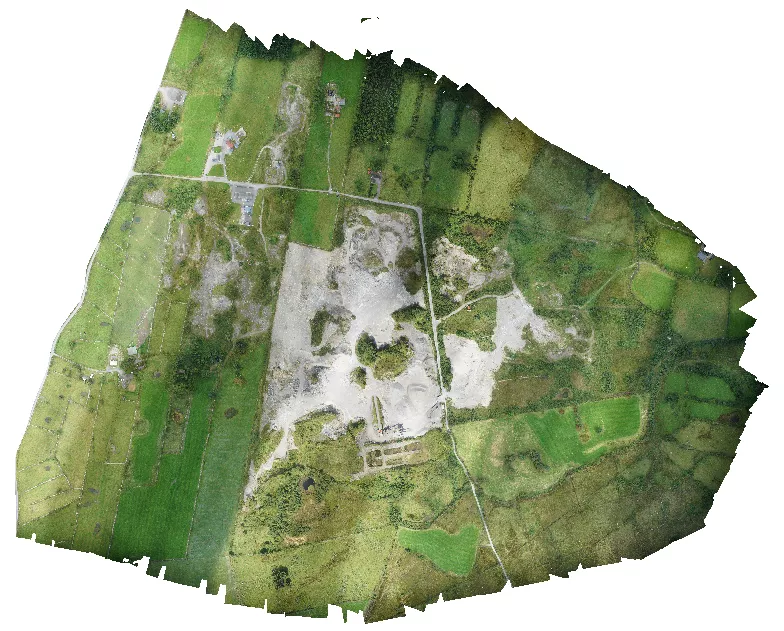
We provide high-resolution, survey-grade 2D maps that far exceed the detail of standard satellite imagery. The technical process utilized is Orthomosaic Mapping, which involves stitching together hundreds/thousands of high-resolution images—each with its own GPS coordinate—into a single, geometrically corrected map.
Unlike a standard aerial photo, a map produced through our Drone Mapping Services Ireland-wide services, is orthorectified. This means the perspective is corrected for lens distortion and topographic relief, allowing for the measurement of distances, areas, and coordinates directly from the map with centimeter-level precision. Whether for planning, boundary verification, or site records, our Aerial Mapping provides the “Ground Truth” for your project.
The 61MP Advantage – Sony A7RIV & GSD
The quality of Drone Mapping Ireland depends on the sensor used. DataDrone utilizes the Sony A7RIV 61-megapixel full-frame camera mounted on a DJI M300 RTK. This high-resolution hardware allows us to achieve a superior Ground Sampling Distance (GSD).
GSD is the distance between the center of two consecutive pixels measured on the ground. By capturing data at sub-centimeter GSD, we ensure that site features—such as utility covers, line markings, and curb edges—are clearly visible and measurable. This level of detail is essential for High-Resolution Drone Mapping where engineering tolerances are a priority.
We prioritise cameras with a mechanical shutter which e.g. our smaller drone, the phantom 4 pro has. This ensures perspective and lens distortion correction can be applied adequately.
Advanced Workflows: Dual-Sensor Efficiency & LiDAR Integration
While many Drone Mapping Ireland projects rely solely on photogrammetry, we specialize in Dual-Sensor Missions that combine high-resolution RGB imagery with LiDAR data collection. This hybrid approach offers a significant efficiency gain, particularly on large-scale sites or areas with complex terrain and dense vegetation.
By utilizing a LiDAR-derived point cloud as the base for orthorectification, we eliminate the need for the time-consuming “point cloud from imagery” phase of standard photogrammetry. This allows for the production of a Digital Twin Ireland-ready dataset with greater speed and structural integrity.
The primary benefit is the absolute vertical accuracy provided by the laser, which is then draped with the 61-megapixel clarity of the Sony sensor. This ensures that the final Drone Orthomosaic Ireland is a survey-grade document where every pixel is correctly positioned in 3D space. This integrated workflow is a cornerstone of our Topographical Survey Ireland and Volumetric Measurement Ireland services, allowing for the coverage of hundreds of acres in a single day of field work.
Data Processing & Survey-Grade Deliverables
The true value of our Drone Mapping Ireland workflow lies in the post-processing phase. Once high-overlap imagery is captured using the Sony A7RIV, we utilize photogrammetry engines like Agisoft Metashape to stitch the data into a seamless, orthorectified map.
Every pixel in these maps contains spatial data, and processed into the appropriate coordinate reference system (IRENET95 ITM for Ireland):
GeoTIFFs (.TIF): High-resolution, georeferenced images used in GIS and CAD.
Point Clouds (Las): Data points that serve as the foundation for 3D modeling and high-accuracy site analysis.
- DXF/DWG: Prior to orthomosaic generation we process the DEM from which we generate contours and export as dwg/dxf for CAD integration
Practical Applications: From Planning to Boundary Verification
Our Drone Mapping Ireland service supports a project through its entire lifecycle:
Site Planning & Design: Create an accurate base map for architects and engineers.
Boundary & Land Mapping: Overlay OS maps onto high-res imagery to identify physical boundaries, fences, and historical landmarks—essential for Drone Boundary Survey Ireland requirements.
Construction Progress: Generate a time-stamped digital record of a site. For Linear Surveying & Infrastructure, this provides a seamless strip-map of roads or pipelines.
Environmental Management: Monitor land usage and topsoil stripping across large-scale sites where ground access may be restricted.
7 Benefits of Professional Drone Mapping Ireland
Unrivaled Detail: 61MP sensors provide as low as sub-centimeter GSD.
Survey-Grade Accuracy: Centimeter-level precision for engineering workflows.
Rapid Data Collection: Cover hundreds of acres in a single flight day.
CAD Integration: Seamlessly export to .TIF, .LAS, and .DWG/DXF formats.
Historical Record: A “Time-Stamped” digital twin of your site at any date.
Cost Efficiency: Significantly faster than traditional ground-based mapping.
Safety First: Minimize personnel time in high-risk site environments.
Safety, Compliance & Airspace Coordination
Executing High-Resolution Aerial Mapping in Ireland requires adherence to aviation safety standards. All Drone Mapping Ireland operations are conducted by EASA-certified pilots operating within the Specific Category.
For sites located in controlled airspace or near sensitive infrastructure, we handle coordination with AirNav Ireland to ensure legal compliance. By securing the required flight permissions and maintaining professional liability insurance, we ensure that high-quality data is captured legally and without site disruption. Whether managing a 1.6km linear road project or a confined urban development, our approach to Drone Mapping Services Ireland-wide ensures professional results.